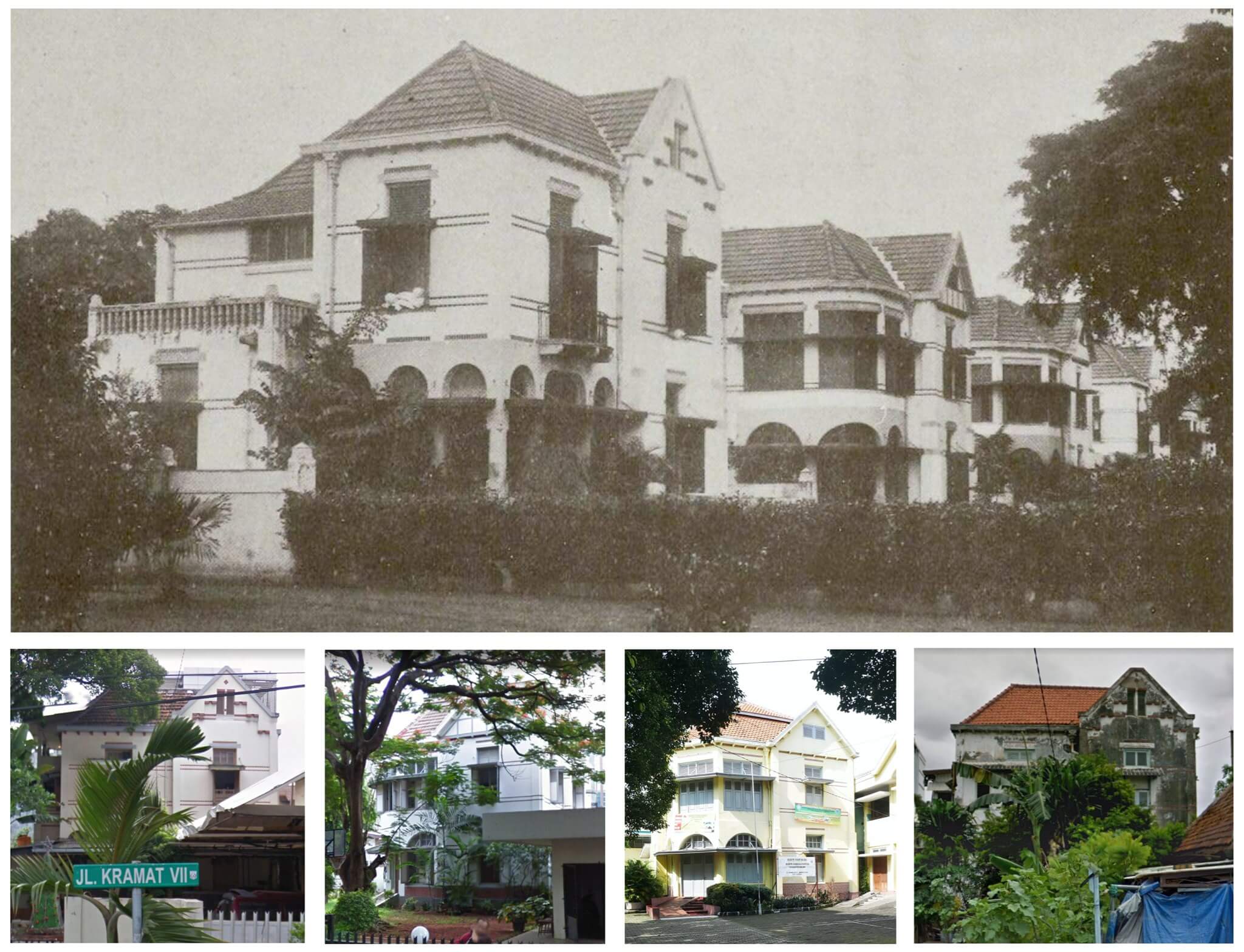
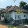
Houses on Jalan Kramat 7 (Laan Wiechtert) in 1912 (above) and now (under)
Most meetings of the Batavia/Jakarta City Council between 1908 and 1911 were dominated by debates and decisions to tackle the city’s severe housing shortage. A newspaper in January 1909 elaborated on the “housing misery” and explained that residential houses in Batavia for middle-income households were too expensive or of poor quality: “Often residents with a small or medium income have to search for houses beyond their buying power or are forced to live in the kampungs”. In 1908 the ‘Bataviaasche Bouwmaatschappij’ (Batavia Building Company) was established with the goal to build good quality and affordable houses.
De Bouwploeg
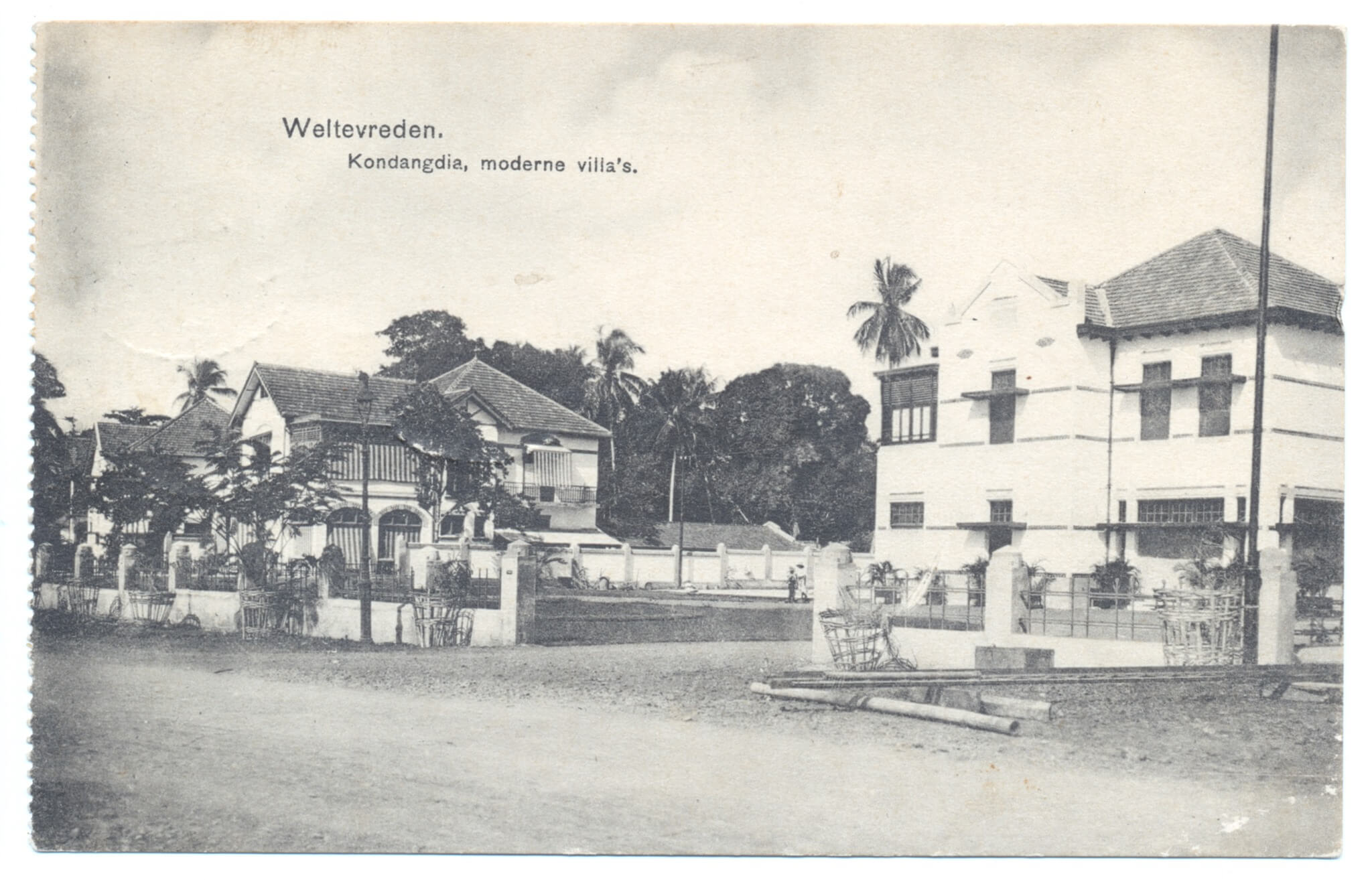
Nearly two years before this company merged into ‘N.V. De Bouwploeg’ and focused on the masterplan for New Gondangdia and Menteng, it started to experiment in Kramat. The company bought a sizeable piece of land that stretched out from Kramatlaan (now Jalan Kramat V) to Salembaplein (now Jalan Kramat VI) and Laan Wiechert (Jalan Kramat VII), all side streets of the main north south Kramat road. On this piece of land were the ruins of the former Kramat Hotel. Architect P.A.J. Moojen (1879-1955), who arrived in Indonesia in 1903 and was partner of the firm Biezeveld and Moojen in Bandung until 1910, had already designed the new dining rooms of Hotel des Indes and Hotel de Nederlanden (1906), the book store of Visser & Co (1907) and the new NILLMIJ head office (1909), all in Batavia/Jakarta. He was commissioned to design 120 new houses along the forementioned 3 streets in Kramat. Moojen used solid materials and most houses featured innovative designs and fittings (more in the next post).
Kramatpark
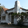
Despite the luxury appearance, especially those with two-storeys, they were still marketed as affordable. The monthly rental price varied between 75 and 125 guilders for a two-storey house. The Bataviaasche Bouwmaatschappij remained the owner of all houses. Only 22 houses had two-storeys. These were built at the end of Kramatlaan (which was called ‘Kramatpark’ in popular speech but never obtained that name officially) and the end of Laan Wiechert (Jalan Kramat VII), close to the Ciliwung River. A number of these two-storey houses do still exist today, of which four adjacent houses on Jalan Kramat VII (numbers 23, 25, 27 and 29) are the most eye-catching. These four houses are all visible on the historic picture from 1912, and in the same sequence on the four coloured photos of 2014 and 2015. We were kindly alerted by Scott Merrillees that a number of these houses do still exist today. All photos are individually posted in the comments below this post too.
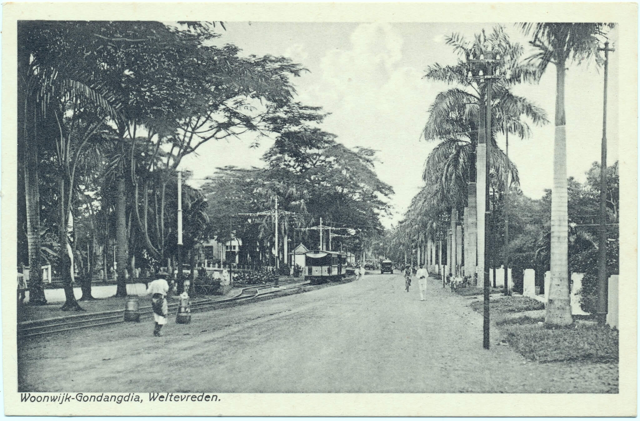
Newly built houses by De Bouwploeg on the southern side of the just constructed entrance to the new residential district of New Gondangdia (now Jalan Cut Meutia). These two-storey dwellings were located on the right side of the road when approaching from the train line, and the photographer stood in front of the Boplo (Bouwploeg) building, now the Mesjid Cut Meutia, which was under construction at the time when the photo for this Kolff & Co postcard was taken. Construction of these houses started in July 1911 and the first families inhabited these as from early 1912.
Wisma Mochamad Romly
The house on the right is now the site of Wisma Mochamad Romly on Jalan Cut Meutia 13, and was already a mess in 1946, then of the Marine Women’s Department (Marva). This house was designed by P.A.J. Moojen (1879-1955) who was one of the most renowned architects of De Bouwploeg. Houses of a similar design were already designed and constructed by Moojen two years earlier in Kramat (more on this soon). The house to the left is situated where today the KPBN office is located, the furthest house to the left is the site of today’s Sofyan Hotel. These two houses were most likely designed jointly by Moojen and other architects of De Bouwploeg. Sadly all houses on this postcard were demolished long ago. There is one original Bouwploeg house left on the northern side of Jalan Cut Meutia: the Bank Mandiri branch at Jalan Cut Meutia 16.
The Batavia/Jakarta City Council approved a plan in October 1910 to construct an entire new residential district on the grounds of the former lands ‘Gondangdia’ and ‘Menteng’. This was urgent as the city suffered from a general shortage of houses, although Menteng/Gondangdia was created mainly for the well-to-do European residents of Batavia/Jakarta. A commission worked out the plans and by 1911 the so-called N.V. De Bouwploeg was established and in charge of the development of the northern half of this district. This was named “New Gondangdia” and covered the area north of what is now Kali Gresik (the drainage canal between Jalan Moh. Yamin and Jalan Sutan Syahrir). Menteng was situated south of this canal. Construction started in July 1911 with the first 11 houses on what is now Taman Cut Meutia.
Gang Baroe Kondangdia
Beforehand this was a small dirt road called Gang Baroe Kondangdia and led to the nearby Kampung Baroe (Baru). However as from 1899 the new electric tram line from Tanah Abang to Tjikini (Cikini) ran through this kampung too. In 1911 the road was doubled to create a stylish ‘entrance’ to the new residential district, with the tram line in the middle, as we can see on this picture. The houses along this entrance all had two storeys and were designed by architects of De Bouwploeg, of which P.A.J. Moojen and Ch. P. Schoemaker were the most well-known.
Entree Gondangdia
Since the establishment of De Bouwploeg in November 1909 the company was based behind the Raad van Justitie (now Museum Seni Rupa dan Keramik) in Kota. In 1912 construction started of an impressive building for De Bouwploeg at the end of the Entree Gondangdia street, next to the train line. It is partly visible behind the trees in the distance, left of the tram. This postcard from Visser & Co dates from approximately 1920 and was taken from the corner of Menteng (Jalan Menteng Raya), Tjikini (Jalan Cikini Raya) and Oud Gondangdia (Jalan RP Soeroso).
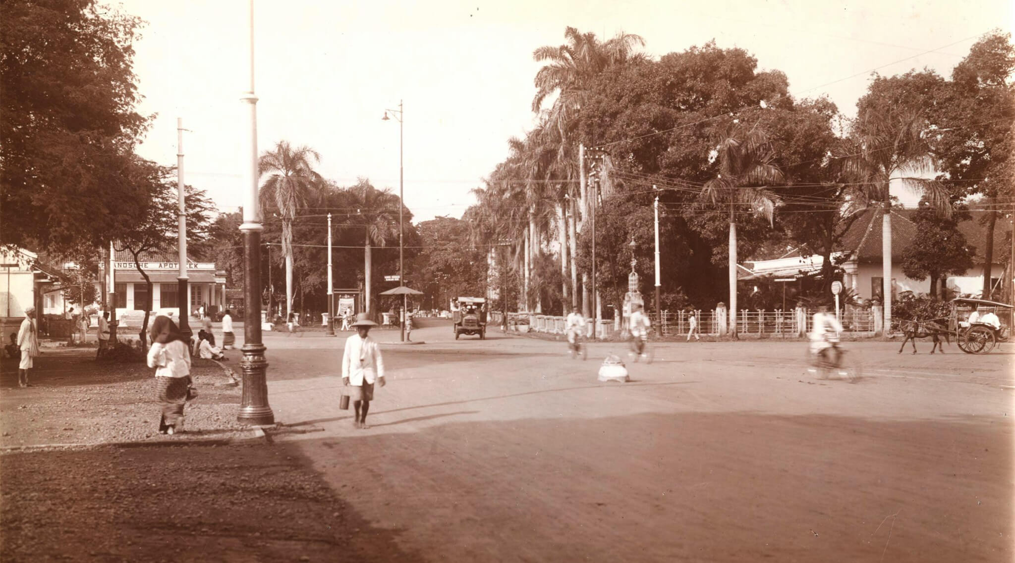
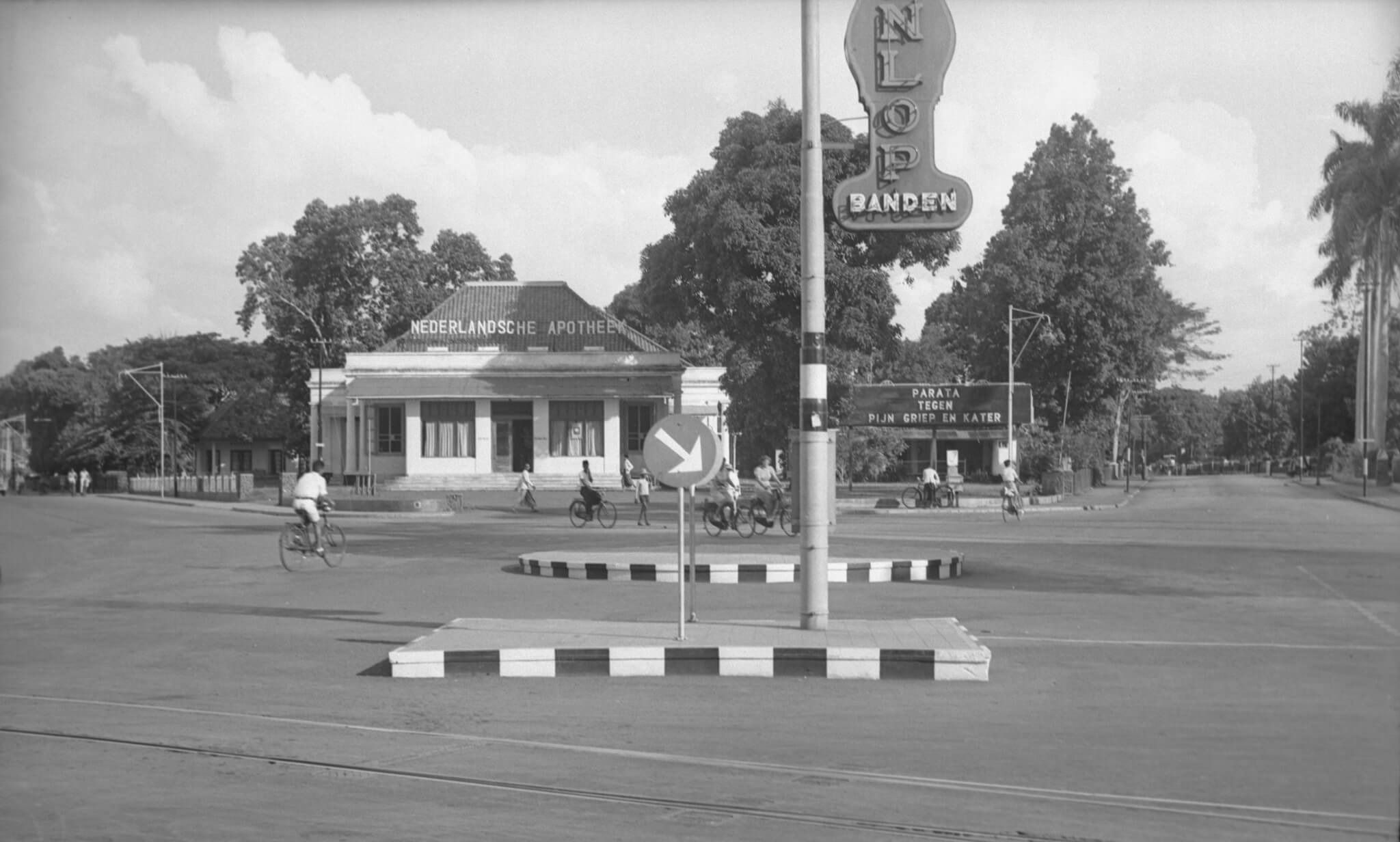
The Cikini Gondangdia (Simpang Lima) intersection in 1935
Following the 1941 view of this ‘simpang lima’ intersection, which we published a few days ago, this time a lovely picture of the same crossing, from a slightly different angle though, from the mid 1930s. From this point at the end of Menteng (Jalan Menteng Raya) we see the nice building of the “Nederlandsche Apotheek” (Netherlands Pharmacy) on the point where Tjikini (Jalan Cikini Raya) and Oud Gondangdia (Jalan RP Soeroso) came together in the distance on the left. This pharmacy moved to this site in November 1925; before it was the private residence of a certain Dr. de Vrieze.
Radjapharma
Up until the end of 1957 the pharmacy had the name “Nederlandsche Apotheek”. Afterwards it most likely changed into “Radjapharma”. The pharmacy existed until at least the mid 1990s when this lovely building was sadly demolished. Now it is the site of the multi-storey Menteng Huis, with Kimia Farma and a HEMA branch. On this picture we look straight into Oud Gondangdia (Jalan RP Soeroso), right of the pharmacy. The delman on the right comes out of the Van Heutszplein (now Jalan Taman Cut Meutia). On the left of this picture, next to the street lantern is the entrance to Huize Vijfsprong on Menteng (Jalan Menteng Raya) 37, a 19th century house that has been entirely rebuilt in its original state in 2018.
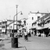
The intersection Simpang Lima at Cikini – Jalan R.P. Soeroso 1941
A unique view of a unique building that stood on this place until at least 1995. During a visit to Jakarta in 1995 I suffered from a tummy bug while staying in a guesthouse along Jalan Gondangdia Kecil. I went to this pharmacy to purchase some Norit and I remember it was still the old colonial era building. This photo from nearly 80 years ago was taken at the so-called ‘Vijfsprong’ where 5 roads came together: Oud Menteng (Jalan Menteng Raya), Tjikini (Jalan Cikini Raya), Oud Gondangdia (Jalan RP Soeroso), Van Heutszplein (Jalan Taman Cut Meutia) and Gang Pengarengan (this road no longer exists).
Nederlandsche Apotheek
We are looking south. Left of the Nederlandsche Apotheek (Netherlands Pharmacy) is Tjikini, to the right Oud Gondangdia. The sign near the drugstore says “Parata, against pain, flu and hangover”. At the front, partly visible, an advertisement for Dunlop tyres. Despite a usual busy intersection, we only see cyclists and pedestrians on this photo. On the site of the former apotik/drugstore is now the “Menteng Huis” with the Kimia Farma Pharmacy and a number of other stores. If any Jakarta residents can tell us more about when the old pharmacy building was demolished, that would be very helpful.
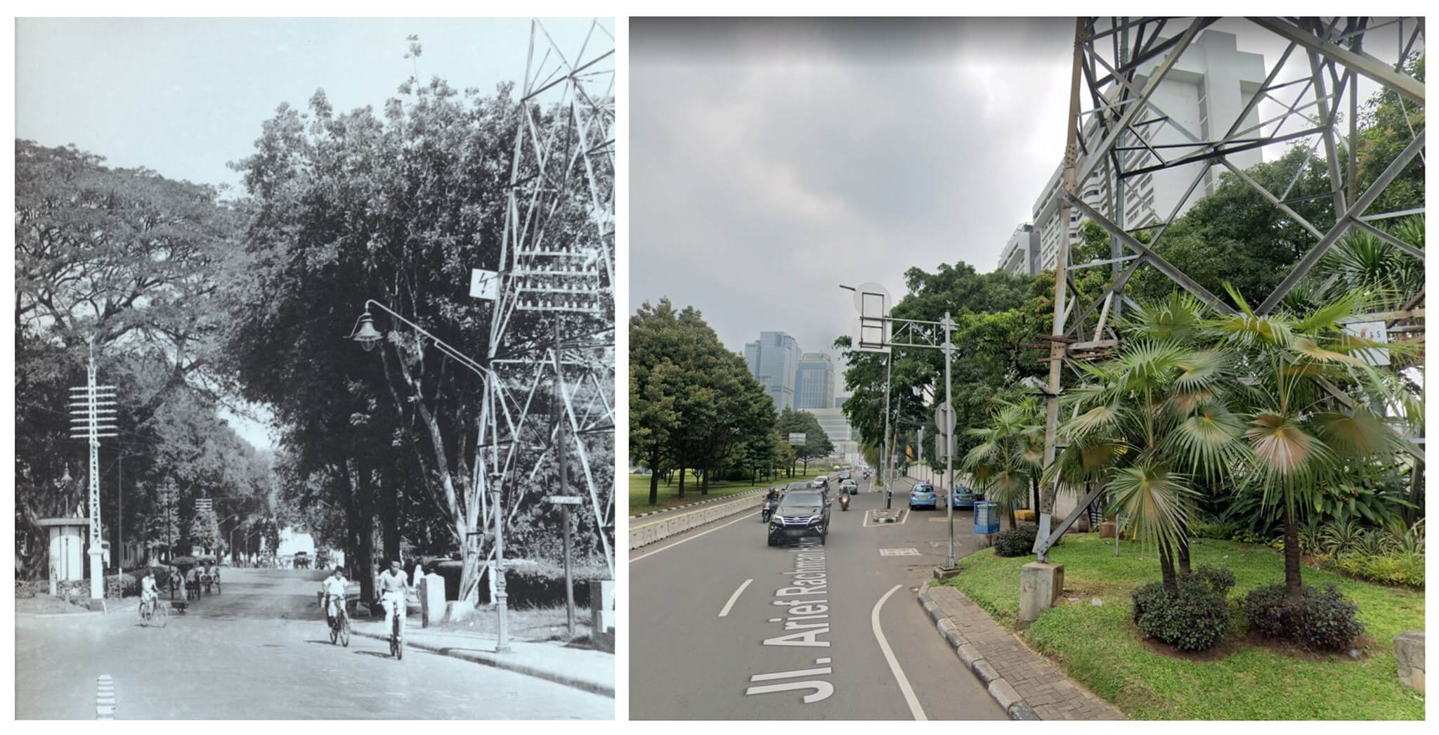
Prapatan electricity pole left (1941) and right (2020)
Thanks to Marc Tierolf who attended us on the electricity pole at the bridge over the Ciliwung River near the Hotel Aryaduta in Prapatan. Despite a few new enforcements, new convectors and different warning signs, the basis structure of this electricity pole is still the same as on the historic picture from 1941. The photographer stood at the edge of the bridge and was looking westwards towards Jalan Menteng Raya (formerly Menteng or Oud Menteng) and Jalan Ridwan Rais (formerly Prapatan Gambir) which started at the end of the road we see on both pictures.
Jalan Arief Rachman Hakim
The street sign near the electricity pole says “Prapattan” which was the name of this stretch of road in 1941. It now has the less romantic name Jalan Arief Rachman Hakim. To the left outside both pictures, the road splits in a southwesterly direction towards Jalan Menteng Raya with the Tugu Tani monument in the park in between. In 1941 there were still houses and other buildings located in this triangular shaped area in between both roads.